Using social media for tourism research
January 19, 2015
Using the social media photography site Flickr to gather data, Irem Önder of the Department of Tourism and Service Management and Alexander Hubmann-Haidvogel of the Department of New Media Technology, along with Wolfgang Koerbitz of the Vienna University of Economics and Business, have mapped out where tourists frequent in Austria.
Their joint paper “Tracing Tourists by Their Digital Footprints: The Case of Austria”, in a forthcoming issue of the Journal of Travel Research, found a new, innovative, and efficient way to find out where the tourists go.
‘’In Austria, traditional tourism data collection includes surveys, interviews and focus groups, however, these methods are both expensive and time consuming. Moreover, there is a lag between the time of data collection and the receipt of that data for analysis. New and more efficient methods of data collection are needed in order for the tourism industry to work with the data more easily,’’ says Dr. Önder.
One way of collecting data is from the Internet, especially from digital footprints left on travel-related web sites, including messages on online forums, uploaded photos, or metadata regarding links clicked on a website. Today, nearly everyone leaves these footprints, which can be used for tourism research. This study looked in particular at photos uploaded on the user generated photo sharing platform Flickr, with the aim to determine whether the digital footprints left there provide a useful indicator for tourism demand.
In order to collect data, an application was developed by Dr. Hubmann-Haidvogel using the public Flickr REST API (Flickr 2012). The application retrieves photos and the corresponding meta-data for a given place (i.e. “Innsbruck/Tyrol/Austria”) for a given time frame, including the tags of the image, geolocations of the photos and the date and time when the photo was taken and uploaded. In this study, photos tagged with “Austria” were collected between March and May 2013.
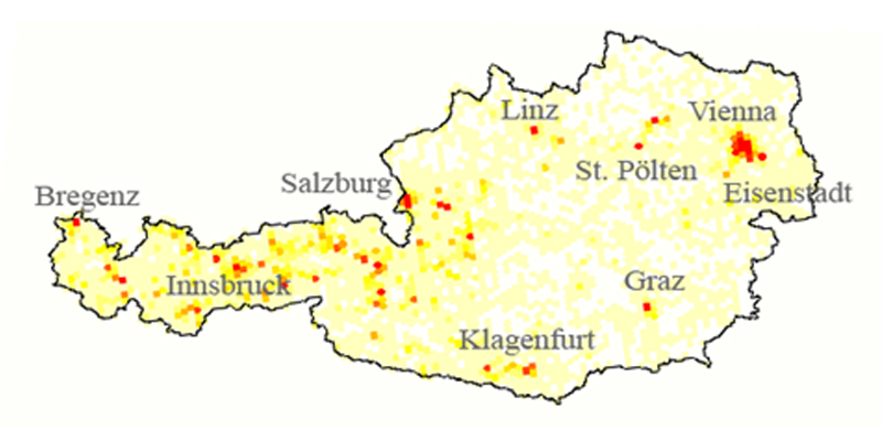
Since the data collected from Flickr include both tourist and resident data, tourist data were filtered out in accordance with the purpose of the study to identify the number of tourists. The above map shows the dispersion of tourists in Austria based on geotagged photos retrieved from Flickr, with red points indicating a higher density of tourists and the yellow points a lesser density. The comparison of regional and city level analyses indicates that geotagged photos in Austria are more representative of actual tourist numbers at the city level than at the regional level.
Data Management Organizations (DMOs) can use this type of information for improving the tourist density in highly-visited areas by implementing different types of marketing to promote the movement of tourists to lesser-known areas at the destination or in neighboring areas. Moreover, the findings show where the tourists have been; thus, DMOs at the city or national level can identify the preferred routes of tourists and thus adjust tourist maps accordingly. In addition, the data can be used for improving and updating public transportation at the destination.
The entire paper is available online ahead of publication.